|
Caverswall - visit before the next Ice Age
comes
Which, do you think is the odd one out – Lord Wedgwood, the Chief Constable of Staffordshire Police, the infamous Victorian fraudster known as the Tichbourne Claimant, or a community of Benedictine nuns?
Answer – the nuns. The others have all had relatives who were owners of Caverswall Castle whereas the nuns were only tenants there. If you want to know the full history you can read all about it at the excellent Caverswall website, better still, read Mike Rogers’ book, The Spirit of the Place – an un-put-down-able village history.
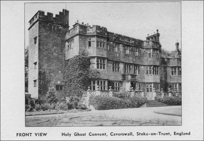
Holy Ghost Convent,
Caverswall, Stoke-on-Trent
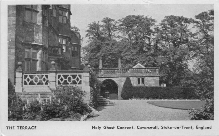
The Terrace - Holy Ghost
Convent
If you travel to Caverswall by train you will have to get off at Longton or Blythe Bridge. There used to be a railway station nearby at Meir but that has gone except for the crossing house which is now privately owned by Gillian and Derek Smith who have converted it to domestic use. In exemplary fashion these owners for the past ten years have retained and have restored the entire railway features right down to the tiny office rooms and railway furnishings and fittings. Even the bathroom tiles have been restored in the old claret and gold colours of the NS Railway Company.
“We bought the house about thirteen years ago but it took us two years to make it liveable,” says Gillian. “It was built in 1845 as the crossing keeper’s house and it closed as a working amenity in 1963. The same architect who designed Stoke station designed this house using the same typical Dutch styled frontages.”
The downstairs toilet and bathroom amenities have been converted into living rooms – a tiny diner – a slightly larger lounge – a pantry and a former downstairs bathroom has been extended into a kitchen. Cupboards have been moved around and solid oak window shutter-doors left as fanciful recollections. Every bit of useful space has been occupied – casual but purposeful timber doors leading to porches are all original. Iron mortise locks with jail-keys have been retained and casement alcove windows give every suggestion that you are indeed sitting in a country railway station waiting room. I half expected Trevor Howard and Celia Johnson to be sharing a brief encounter in the dining room corner as a passing Crewe train rumbled slowly east bound.
Inquisitively I climbed to the crossing signal box to speak to the duty operative. “Not supposed to be here,” he remonstrated and ushered me off. But not before he filled me in with some useful information about the crossing and it’s past. I didn’t actually realise before just how important this line is. Incredibly it travels all the way to Skegness and thirty trains pass over the crossing each day. It takes 15 minutes to travel from Stoke station to Uttoxeter a distance of 16 miles across a gradient of 116 to 170. Now that’s what I call civilised travel.
Mike Rogers is the expert historian on Caverswall who originally comes from the Forest of Dean. Mike arrived by train to North Staffordshire in 1957 and told me,
“The name Caverswall is taken from the Anglo Saxon which was Cafhere’s Wall, the name of a son of a Saxon landowner, possibly the holder of the main settlement at Weston or the one further back at Werrington. It was known as the ‘circle of possession’ whereby the sons of the landowner would move away as they came of age to set up on their own. Cafhere was this particular son’s Christian name who moved to the edge of his father’s ‘circle of possession’ taking advantage of suitable ground centred on a well.”
Settlements in the Caverswall area do indeed seem to be about two and a half miles apart. The wells that were abundant in Anglo Saxon times were fed from the steep slopes of a terrace of sandstone rock seen in exposed outcrops at nearby Hulme. The flow of water ran to the River Blythe and then on to the Trent. On the high ground there was an oak forest which was ideal for rearing pigs whereas the middle ground was perfect for grazing sheep. The lower land was dammed giving villagers an abundance of fish and fowl. Damming also created rich pastures sufficient to feed a community with oats and
wheat.
In 655AD a Christian hermit named Chad was active in North Staffordshire during the period when the King of Mercia, Wulfhere, established a camp at Stone. His sons, Wulfad and Rufin, met Chad and, as Mike considers, “It is not unreasonable to think that the ministry of Chad took place around Caverswall thus introducing early Christianity to these parts in this very place.”
Walking along Caverswall’s top road Mike pointed out a variety of landmarks such as a ‘glacial erratic’ – that is a stone left by the receding Ice Age. We also came across evidence of a lively spring. “This one,” says Mike, “may actually have been the one that gave the name to the Cafhere’s well – it is very likely in my opinion.”
Nearby there are some cottages that stand back from the main row of houses. “This is called ‘The Crocket’,” says Mike. “I was unable for a long time to discover the name’s origin but ongoing research has helped me to discover that there was a marl-pit field and a kiln-field here. Quite by chance I found that the Saxon word for pottery was ‘croche.’ I believe my investigations indicate that a Saxon pottery was founded and located right here. Certainly very old pottery shards have been unearthed by residents of nearby gardens.”
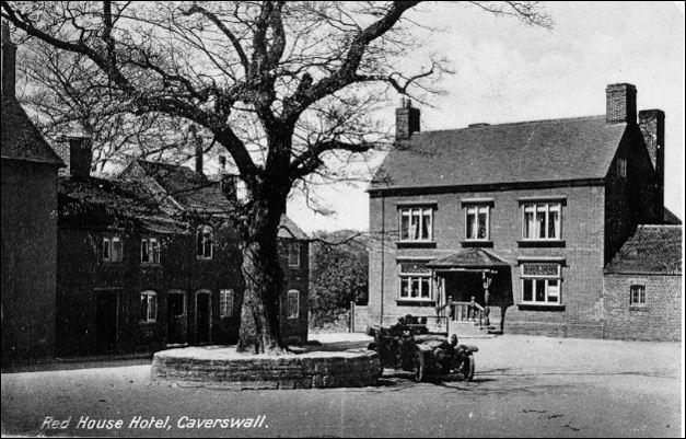
Red House Hotel,
Caverswall
postcard: John Booth
Caverswall has a constituent population of 2000. That doesn’t mean of course they all live in the village; indeed very few live here and those that do are like protected species – they are very rarely seen.
The bar staff in the village pub, The Red House, have their time taken up serving lunches to tourists. Maureen Lester has worked here for 20 years. “I’m from Meir,” she tells me. Do many locals actually use the pub, I ask? “Well mostly they do in the evenings. But we have a football team that is based here.” But is it local, I persist? “Well I don’t really know. I suppose not,” Maureen thoughtfully considers.
Louise Walchester is the other person on duty – she also comes from Meir. “There is a mixture of local customers,” she confirms, “But they’re mostly young people. The pool room and the bar is the place most locals gather.”
I venture that the pub looks like the Bull at Ambridge probably does without the Grundy’s, Squire Brian Aldridge and the probably 100 year old Phil Archer. Louise looks blankly at Maureen who in turn looks skywards sympathetically as though to say to the younger woman – ‘I’ll explain it when he’s gone.’
Time moves slowly inside the Red House, and long-serving Maureen is hard put to recall an event more important than a rare visit from the Sentinel’s Alan Cookman who sampled the food and reported on it – ‘was it five years ago?’ she avers.
The Red House is an old pub that bears the proclamation on its sign above its door – ‘Rum-tum-tardy-um’ which, I am told, was the chorus to a marching song of the Caverswall Volunteers, a sort of civil defence brigade, a Dad’s Army raised when there was a threat of invasion by Napoleon.
The village is full of surprises, notably the punishment stocks that lie beneath a huge tree in the middle of the Market Place. Then there are the full set of churches standing in a row – Catholic, Anglican and Wesleyan although the old non-conformist chapel is now the office of Ian Parry who runs his PR business from
there.
Ian is a district and county councillor who says, “It’s a lovely place to come to work; peaceful in the daytime and a comforting mile away from my home. But the surroundings of course are steeped in history and it is always tempting to break off just to stroll around taking it all in.”
Next door to his office are the splendiferous castle towers with stone stretch-ramparts set in the middle of a dry moat. And what great history is held here! Famous Staffordshire families have lived in these Jacobean-styled halls ever since Cafhere’s settlement – Saxons, Normans, Civil War Royalist and Puritans; rich families and reclusive clerics.
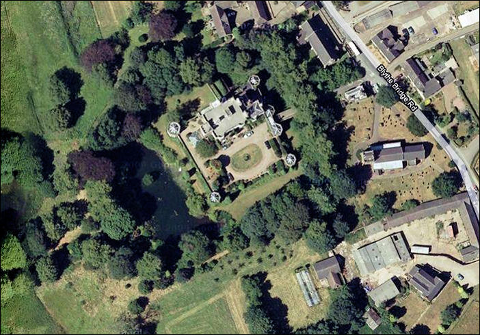
Caverswall Castle -
Google Maps 2011
The castle once had its own cricket ground when in 1889 the then owner, William Bowers, created Caverswall Cricket Club in the grounds. Today the ground has moved over the border into Weston Coyney but still keeps its old name. Here I meet club chairman, Alan Gott and long-serving member Les Stott.
“The club used a field at the rear the castle for the playing area and pitch,” says Alan. “And this featured a thatched pavilion. The Castle later passed into the hands of an Order of Nuns, and during the early 1940s the Club was given notice to quit.” Les continues, “In the post-war period the Club found temporary sites at Meir aerodrome and at Bolton Gate. Eventually, in 1957 this new ground was purchased. It was the year the Club left the Blythe Bridge and District League and joined the North Staffs and District League. Actually we’ve never looked back.”
A physical chronological history of North Staffordshire from the Palaeolithic Period to the Industrial Revolution can be found in Caverswall. The intrepid villagers, wherever they are hiding, are making sure through historical preservation that Caverswall will be here for anyone who wants to see it – so long as you visit before the next Ice Age comes.
Fred Hughes

|