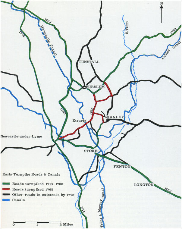
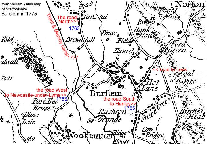
Trubshaw Cross & Brown Hills:
The Act of Parliament for making the present Turnpike Road,
(passed in 1762), describes the road from Tunstall to Newcastle,
as "going by Trubsharv Cross, and the Tan-House,
(Wolstanton), down Sparks's Hollow, over a common field, called
the Brampton, to Newcastle ; and another branch extending from
Burslem to Trubshaw Cross, aforesaid".
The Ash Estate:
The road running from Hanley to Cheadle road turnpiked in 1771.
“Ash”, a large Elizabeth house, stood on the south side of the
road on the site now occupied by the Ash Bank Hotel. It was the
chief estate in the township of Eaves, part of the parish of
Stoke-upon-Trent.
The other important
feature was Wetley Moor. Handley Hayes, an estate on the edge of
the moor, was the site of a colliery which had been in existence
since at least 1772. Coal carts from the colliery used the present
Brookhouse Lane which led from the moor to the turnpike road.
Meir & the route of Rykeneld
Street:
"This road proceeded from Blyth Marsh, in a direct course towards
Lane End… the Sutherland Road in Lane End is a continuation of it;
at the north end of which it again unites with the turnpike road,
and passing the church, goes on to Lane Delph; but there the
turnpike road diverges a little..."
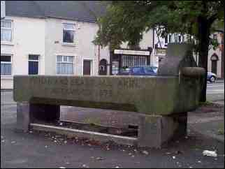
The Ivy House Estate:
Diagonally opposite the 'Ivy House' public house - an old horse
trough. Note the fountain on the side for human use.
The reason for the drinking trough was that
this was the site of the Ivy House Toll Gate. This stood until the
1870's. There was one at the Junction of Keelings lane at Upper
Green in 1820 and one to the South West a the junction of Hulton
Street and Town Road
Waterloo
Road:
Burslem to Cobridge: The northern section from Burslem
to Cobridge was built between 1815 and 1817. As a result the old
narrow winding turnpike road was replaced a straight wide road.
The new road immediately became a focus of new development.
William Adams, of Cobridge Hall was one of the first to exploit
the potential of the new road.
Adderley Green:
The road to Adderley Green followed the course of Wood Street
originally. Under and Act of 1813 a new turnpike road to Adderley
Green, the present Anchor Road, was built. This road was
disturnpiked in 1877 and declared a main road under the Highways
and Locomotives Act of 1878.
Etruria:
Below Wedgwood's new factory built in 1769 were a series of
courtyards next to the turnpike road to Newcastle-under-Lyme. On
the other side of the canal in Stone pit field was the site of
Etruria Hall.
Josiah Wedgwood also purchased land on the other side of the
turnpike road thus creating a compact estate of about 250 acres on
the East side of the Fowlea Valley.