| Districts | Streets | Maps

Stoke-on-Trent Districts: Normacot


next: Normacot in pictures
previous: the need for water

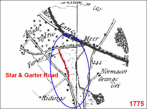
Normacot, Sand and Gravel Quarries:

A 1725 map shows ‘sand holes’ and ‘clay pits’ dug on the west side of Star & Garter Road – under lease from Lord Gower of Trentham Hall. These are replicated the 1775 Yates map shown below.


By 1834 the largest operator was William Grindley, in 1919 Quarry in hands of Benjamin Hilton and John Wardle.


Normacot from Yates 1755 map
showing the location of the sand and gravel quarries (blue circle)
the location of Star and Garter Road has been added.


The Star & Garter Road, Normacot c. 1900
The quarries can clearly be seen to the left of the picture

© The Lovatt Collection


Summary of Normacot history from the maps:


Roman Road

Hulton Abbey and Normacot Grange

Lightwood Forest

Water Supply – springs and brooks

Coal and ironstone mines

Sand and gravel quarries

Furnace – iron smelting to vicarage 


next: Normacot in pictures
previous: the need for water