|
The early history of Stoke:
The first centre of Christian
preaching and worship in the area was situated neither in the
ancient village of Penkhull nor in the town of Newcastle.
From as early as
the Seventh Century AD, it stood in the valley at the place where
the infant River Trent met the even smaller Fowlea Brook. The name
given to this ancient place of meeting and worship was
"Stoke-upon-Trent.''
The name "Trent"
was originally Celtic and meant "the trespasser" or "the flooding
river." "Stoke" comes from the Anglo-Saxon word "stoc," which
meant in the first instance "a place," but carried the usual,
secondary senses of "a religious place, a holy place, a church,"
and "a dependent settlement." Either of these secondary meanings
could be applied to our "Stoke," since it was originally dependent
upon Penkhull, and for centuries consisted of little more than the
church and rectory.
Stoke and Domesday
(1087)
Of the principle six towns of the city
only Burslem and Fenton are in existence at the time. Included in
the description of Caverswall is a mention of a church at Stoke but
no description of any land or settlement, presumably the church
served nearby Penkull.
CAVERSWALL
[CAVRESWELLE]
STOKE (-ON-TRENT)
[STOCHE] |
|
In CAVERSWALL 1 virgate of land.
Arnulf holds from him.
Wulfgeat held it; he was a free man. Land for 4 ploughs.
In lordship 1;
10 villagers and 2 smallholders with 3 ploughs.
Meadow, 6 acres; woodland 1 league long and ½
wide; A half of Stoke(-on-Trent) Church, with
1/3 carucate of land.
Value 30s. |
The map below shows Stoke in
1775.
Stoke was then described as a village
and consisted of a line of houses on both sides of the turnpike road
(now Church Street and Hartshill Road). The houses ran from St.
Peter's Church to what is now Shelton Old Road at Cliff Bank.
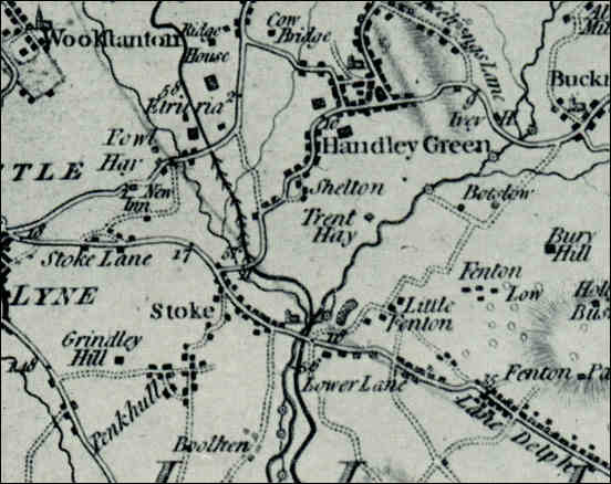
Extract from William
Yates 1775 Map of Staffordshire
- showing Stoke
- click for
larger map -
The river Trent is shown on the map coming from the
top right corner, through Stoke and on past Boothen.
The black line crossing the Trent and running up to
the left through Etruria is the Trent and Mersey canal, building of
which began in 1766 and was completed in 1777. The Fowlea
brook is shown to the left of the Trent & Mersey canal.
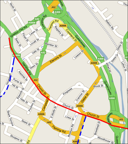
Current day map of Stoke with the Yates 1775 roads and tracks marked
In 1775 the main
road from Longton to Newcastle (shown in red) went through Stoke as
Church Street and then along Hartshill Road (having replaced the
detour via North Street and Stoke Old Road).
Two tracks existed (shown in blue) - one up Honeywall bank to the
ancient village of Penkhull and one along the what is now Longsdale
Street and Campbell Road to Hanford.
|