|
Stoke Church - the
Glebe land:
Glebe Street in the town centre of Stoke is only a few hundred
yards long but contains 14 'listed buildings' (although some are not
buildings but tombstones in the church yard) and Brook Street,
which runs off Glebe Street contained 5 'listed buildings'.
Why the name -
Glebe Street?
In the past, parishes were maintained out of the land attached to
the church (the glebe) and the revenues from the faithful....
Rectors were not salaried, but held property in the parish as
their "living".
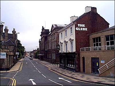
Glebe Street
looking towards Church Street.
-
Just visible on the
far right is the edge of the City Civic Centre.
-
"The
Glebe" is the Glebe public house and hotel.
-
Just visible past the
Glebe, on the pavement, are the bollards which mark Aqueduct
Street.
-
The
old Town Hall occupies the centre of the right hand side of the
street.
-
Past the Town Hall, at
the bottom of the right hand side is a block of 15 shops.
-
On the left of the
photograph are the buildings which occupy Brook Street.
-
Just
visible at the bottom left of Glebe Street are the trees which
surround St. Peter's Church.
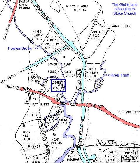
The map below shows
part of the glebe estate, land belonging to the church. This
estate comprised over 150 acres with a third of the land in the
township of Penkhull, a third in Shelton (north of the Fowlea Brook)
and a third in Fenton (east of the River Trent).
The church and the
rector's house (Stoke Hall) stood on moated sites which provided
protection not only from attackers but also from the river which
periodically flooded the meadow land in the valley bottom.
This
map is undated but it is between 1800 and 1826. 1800 is when the
Newcastle Canal (shown on the map) was completed and 1826 which is
when work on the new church was started. The streets around the new
church (Glebe Street, Wharf Street and Brook Street) were laid out
in 1830 and are also not shown on this map.
The Glebe Land
belonging to Stoke Church c.1800-1826
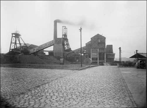
Fenton (Glebe)
collieries Ltd. (1865-1964).
This colliery
derives its name from its association with the glebe lands of the
parish church of St. Peter ad Vincula, Stoke.
The road alongside the location of this colliery is now called
Glebedale Road
|