|
Trubshaw Cross:
The
development of the roads, industry & commerce ....
"The road running
north and south through the Potteries was at first only a side way
from the main road from Cheshire to Lichfield through Newcastle and
Stone.
In 1763, however, it was turnpiked as far south as Burslem—a triumph
for Josiah Wedgwood and the potters over the vested interests of
Newcastle.
The
road from Brownhills to Trubshaw Cross (presumably the stretch known
in the 17th century as Smallbridge Bank) was also turnpiked under
this Act, and so was the road from Burslem to Trubshaw Cross (Pack
Horse Lane). Thus Tunstall and Burslem were linked with Newcastle.
The line of the road
from Burslem to Trubshaw Cross was subsequently altered so that it
became the present Newcastle Street, and in 1828 the old road was
sold. Enoch Wood bought the part which ran through his Fountain
Place Works; the eastern end of this stretch, running from Westport
Road down to the entrance of Ford and Sons' pottery, still survives
and retains the name of Pack Horse Lane.
The course of the road
through Longport was diverted in 1848 to run on its present more
southerly line, and a bridge was built over the newly opened
railway.
In 1858 a new canal bridge was built at Longport and the road there
widened."
From: 'Burslem:
Buildings, manors and estates', A History of the County of Stafford:
Volume 8 (1963)
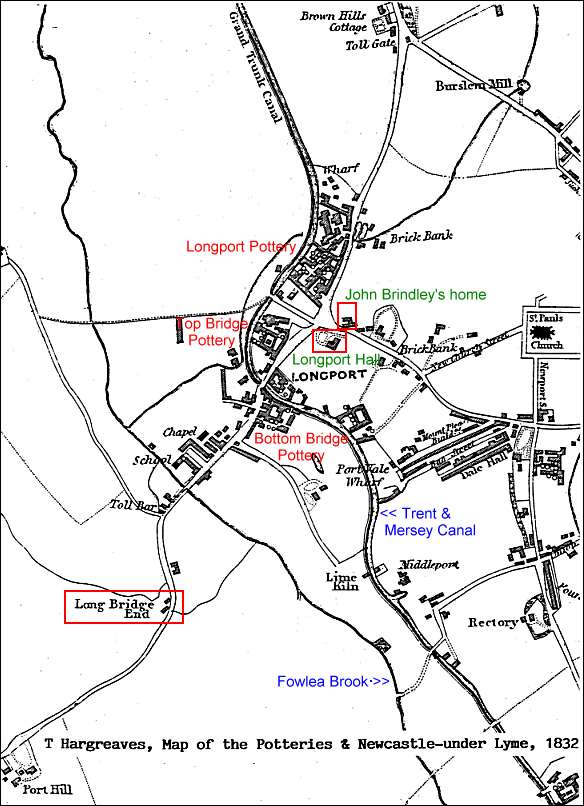
T Hargreaves, 1832
Map of the Potteries &
Newcastle-under-Lyme - Longport Area
The above 1832 map shows the rapid development of the area when
compared with the earlier 1775. All of this development was due to
the proximity of the canal and main turnpike route and the Davenport
pottery factories.
The toll bar and gate near Longbridge End, on the way to
Newcastle, and Brown Hills Cottage on the way to Tunstall are
clearly seen.
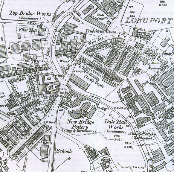
1898 OS map of Longport
This 1898 map shows the development of the
streets and the pottery factories in the area. Although clearly defined on
the map as Longport the presence of Trubshaw [Trubshawe] Cross at the
important road intersection has not been lost.
Keates's
Gazetteer & Directory of the Potteries and Newcastle 1892
record the following trades and shops at "Trubshawe Cross"......
|
Barlow,
Frank |
monumental
mason |
|
Bellingham,
George J |
picture
frame maker |
|
Bellingham,
William |
confectioner |
|
Bickley Bros |
drapers |
|
Lines,
Richard |
watch &
clock maker |
|
Liverpool
Victoria Friendly Society |
Harry Ibbs,
district superintendent |
|
Mawdsley,
Cyrus H. |
baker |
|
Preston,
Fred |
builders
merchant |
|
Sale, Thomas |
cooper |
|
Scragg, John |
confectioner |
|
Tabbenor,
Richard |
greengrocer |
|
Turner,
Henry |
hosier |
|
Wood,
Charles |
shopkeeper |
|
|