Fenton - Stoke-on-Trent
| The 1842 map below shows the two townships of Fenton - Fenton Vivian which lies mostly to the North of the main Longton to Stoke road and Fenton Culvert which lies mostly to the south. |
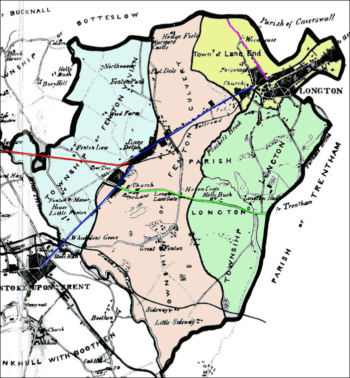
Fenton from 1842 map of the Borough of
Stoke-upon-Trent by Michael Scott
(from Ward's book of the same name)
Blue line
the main road from Longton to Stoke,
which is King Street, City Road and Church Street
Red line is Victoria Road from Fenton to
Joiners Square (leading to Hanley)
Purple line is Anchor Road leading from Lane
End to Adderly Green
Green line - Glebedale Road (was Station
Road) and Blurton Road leading through Heron Cross and Blurton.
|
Historically
Fenton consisted of the two townships of Fenton Culvert or Great Fenton
and Fenton Vivian or Little Fenton. The 1842 Scott map (see above) refers to Fenton Culvert and Fenton Vivian; the earlier Yates map of 1775 (see below) refers to Great Fenton and Little Fenton. In 1832 the River Trent formed the boundary of Fenton to the west and the Cockster Brook to the south and the east (the common boundary with Longton), while the northern boundary adjoining the township of Botteslow followed an irregular line with no geographical significance. Fenton Vivian lay north of Fenton Culvert; (see the 1842 map above) ..... the boundary between the two townships ran from the River Trent south of Stoke Bridge to join the road from Longton to Stoke at the corner of the present Napier Street and then ran in a loop north of the main road to rejoin it at the junction of what are now City Road, Manor Street, and Christchurch Street. It then continued along the main road, Park Street, and Fenpark Road to Pool Dole and then to the Caverswall boundary.
|
![]()
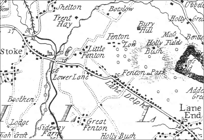
Extract from William Yates 1775
Map of Staffordshire - showing the Fenton area
| The 1775 Yates map shows three main centres of population: Great Fenton
(Fenton
Culvert); Little Fenton (Fenton Vivian) and Lower Lane; Lane Delph.
These areas grew and developed mainly a result of the growth of the pottery and mining industries. Lower Lane and Lane Delph lay along the main Longton to Stoke road and were according to the Yates map the most populous parts at this time.
|
![]()
![]()
Questions, comments, contributions? email: Steve Birks