|
Laying out the
streets of Hanley (Lower Green)
In the 1830's Hanley was considered 'a large modern town', the largest in
the Potteries and the second in Staffordshire; its streets 'generally
spacious and well paved', its houses of 'neat appearance, and some of them,
as well as the public edifices . . . spacious and elegant'. On the
other hand much of the town was overcrowded and insanitary. In 1850
it was noted that 'the principal streets have some good shops; and there has
been lately finished a range of shops far above the standard of everything
else in the Pottery district'.
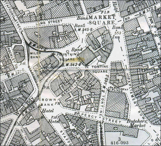
Hanley town centre from an
1898 OS map
In the first third of the 19th century the ground plan of the present
town-centre, including the area round Piccadilly and Pall Mall (in Shelton
Township), was
completed.
The streets in the rectangle formed by Albion Street, Lichfield
Street, Mollart Street (then Union Street), and Bethesda Street on the south
side of the town, much of the area around Hope, Hanover, and Union Streets
on the north side, and many of the streets on the eastern slope above the
town had been laid out. Charles Street and Well Street represented the
beginning of development in the Wellington area to the south-east.
A History of the County of
Stafford: Volume 8
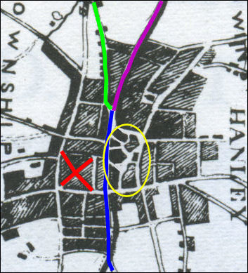
Hanley town centre from an
1842 map
Blue line is Stafford Street.
Purple line is Bryan Street.
Green Line is Hope Street.
The red cross marks the position of Piccadilly and Pall Mall
The yellow oval locates the main squares and open areas.
Everything to the left of Stafford Street was
in Shelton and to the right in Hanley.
Island Sites
The centre of Hanley preserves the irregular
layout of the late-18th-century village and in 1960 Mr. J. W. Plant
the City Reconstruction Officer described it as 'an archipelago of island
sites'.
The buildings occupying these variously shaped
islands have been replaced piecemeal from the early 19th century onwards and
are now of widely different heights, styles, and materials. Because of
Hanley's development as an important shopping centre and the large scale of
its later commercial buildings this lack of uniformity is even more
pronounced than in the other Pottery towns.
A few low-built brick houses
dating from the first third of the 19th century have survived, notably in
New Hall Street, Parliament Row, and Tontine Street. On the south side of
Fountain Square the French Horn public house and the single-story shops
adjoining it are of this type.
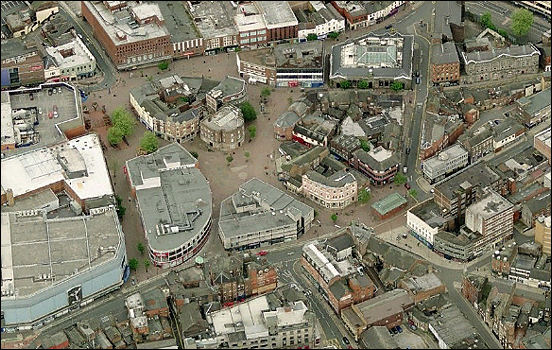
Hanley town centre - 'an archipelago of island
sites'
2008 - Microsoft Live Earth
These 'island sites' consisted
of Market Square (and Upper Market Square), Fountain Square, Tontine Square,
Miles Bank and Crown Bank - these areas all ran into one another and
occupied the area between Market Street (current Parliament Row) at the top
and Stafford Street at the bottom.
|