Historian Fred Hughes writes....
IN ANCHOR Road, Adderley Green, I
bump into historian Steve Birks examining a couple of maps.
"For some time I've been planning to see if I can
locate the old roads of Stoke-on-Trent," he says. "Many have been
obliterated mainly by modern bypasses but it's surprising how many of the
old roads can still be traced. "Of course, some of the important highways
have been relegated to side roads and others have been buried under
housing developments and business parks. But many are still traceable. I
have it in mind to rediscover them and put them on a new historical map."
Steve has me hooked.
"Take Anchor Road for instance," he continues.
"Originally it was a country lane that linked Dividy Road and Park Hall
Road where the gasometer is. The road is extremely busy these days but I
want to see how it must have looked a couple of hundred years ago. It
actually runs straight into Longton town centre. Part of it isn't original
and that's the mystery"
|
|
Steve's early maps show
Adderley Green as a manorial estate with a large mansion surrounded by
open fields and a series of opencast mines dotted here and there. But
later maps show how the district rapidly changed with the arrival of
industry. "Anchor Road was a lane that has been built over by the
roads that serviced industry," says Steve. "And some side roads
suddenly appear as though from nowhere. The site of the mansion has
been replaced by an industrial estate.
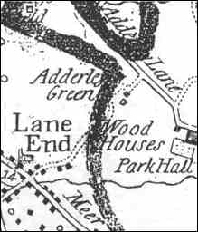
Top map - junction of
Adderley Lane (now Dividy Road) and Anchor Lane (now Anchor Road) from
the 1775 Yates map.
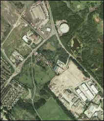
Bottom map - Satellite view
of the gasometer at the top of Anchor Road. The industrial estate at
bottom right is the site of
Adderley House, the
residence of Mrs Walklate in 1851, from Google maps.
 click for more on Adderley Green
|
"I'm searching for the history you don't see. The
history that you know is there but lies buried. Fancy coming along?"
I do, I say, but meanwhile I have a bit of
history to look for myself. Steve's maps go back to the middle of the 18th
century when the land was filled with working coal mines.
|
Retired local bobby Pete Addison remembers the district much
later when he patrolled these streets.
"The number one beat in Longton stretched along Sutherland Road taking
in Market Street," begins Pete. "It covered King Street before it
started up Anchor Road all the way to Park Hall where the Longton
bobby had an arranged meeting with the Hanley bobby at the Wagon And
Horses in Dividy Road.
"A suitable place, I might add," he chuckles. "It was a big area to
cover. Along Park Hall Road was a colliery known as Stirrup And Pye.
This became Percy Trentham's works at a time when gravel was being
taken from Park Hall by Hilton's. And along the way was the Safari
Park Club. All this was the manor estate beneath which the mansion
lies buried." |
From the late 1890s, Anchor Road became the
connecting thoroughfare to Longton.
It still is as it climbs to a ridge where the big colliery of Mossfield
sidled along its slopes. The entrance was bv Banburv Street where the old
Railway Inn kept hospitality, renamed after the pit closed to become The
Corner Pin. "I don't remember when it was renamed," says landlord Chris
Morris. "There used to be a rail line just in front that ran between
the collieries. There was a long row of terraced houses opposite alongside
the railway which have been replaced by council bungalows. Nothing stays
the same for long does it?"
Mossfield was bigger and deeper than Stirrup And
Pye, with shafts descending more than 320 yards. It was one of the oldest
pits in Stoke-on-Trent.
"I've
worked at both pits," says 86-year-old Dick Amison.
But Dick had a more important role to play as the licensee of another
pub that changed its name, from The Prince Of Wales to Last Order's.
"Ah dunna lark how thee change names of pubs," grumbles Dick. "I kept
yon for 28 years. The landlord who had it before me was Bob Dixon. He
kept goal for Stoke in his spare time. "When the war ended I'd worked
most places but my missus wanted to get out of the pots and it was her
that kidded me into going into pubs.
"They've knocked it about since, so they tell me, coz I wunna go in
since I finished with it.
"It's all changed around here now. Dust know, there was a time when I
could stand outside the Prince and see the top of the railway bridge
in Longton. The land has sunk 10ft over the years and they've built
all these houses on it now. It inna the same view anymore." |
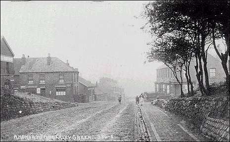
Anchor Road, Adderley Green
An old postcard - looking
towards Dividy and Park Hall Road.
On the extreme left is the 'Railway Hotel' (now the 'Corner Pin') - the
road cutting across Anchor Road is Bambury Street to the left and Short
Banbury Street to the right.
The 'Railway Hotel' was so
named because of the 'Longton Adderley Green & Bucknall Railway' line
which ran across Anchor Road.
click for
more on Anchor Road
There seems to be a hundred pubs in Anchor Road.
"A lot have been knocked down," recalls Pete
Addison. "One of the most popular was the Half Way House. That's still
going strong. The landlord in my time was Jimmy Dewsnap. He was a popular
bloke. Everybody knew Jimmy. Folk would come for miles just because he
kept the best pint around."
Potbanks as well once lined Anchor Road as it
falls south from the ridge where the Workingmen's Club is. Near the
bottom, at the Longton end, I meet up again with Steve Birks and his maps.
"I'm looking for the site of a moated house
built by potter John Carey. It was close to some of the Pottery Chartist riots,"
explains Steve. "It was at the bottom of Anchor Road by Sutherland Road.
The route was changed by turnpike in 1813. Then the original Anchor Road
followed the winding Wood Street."
And there we have it. The road to Adderley Green
actually began in Wood Street where cobblestones by the side of the Crown
Hotel, opposite some delightful single-storey cottages, indicate how it
might have looked then. The Anchor Road we know today wasn't developed
into a main road until 1878.
"I'm searching for similar lanes from Meir to
Tunstall," says Steve. "Do you want to join me?" By this time I'm yards
ahead of him. "Come on," I say. "What are we waiting for?"