| Districts | Streets | Maps

Stoke-on-Trent Districts: Lane End


Next: Maps on Lane End and Longton


Location of Lane End and Longton..........

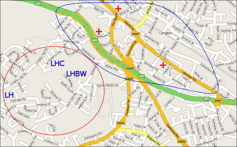
Current Map showing the location of Lane End (blue area) and Longton (red area)
LH = Longton Hall; LHC = Longton Hall Colliery; LHBW = Longton Hall Brick Works
+ by Wood Street was the site of St. John's Church of England church.
+ by Chelson Street is the site of St. James' Church of England church.
+ by Heathcote Road Street was the site of the Roman Catholic church.


Lane End and Longton were two separate townships


Lane End,  Longton, Stoke-on-Trent, Staffordshire.

Confusion often arises over the location and names of  Lane End and Longton. Originally they were two separate and contiguous townships which were incorporated in the of Borough of Longton in 1865.   

Longton was adjacent to Longton Hall and encompassed the Longton Hall Colliery and Brickworks. Even in 1900 the area was mainly fields.

Lane End was centred on the area around Market Street and the bottom part of Anchor Road and contained the Markets, Churches and main potworks.


The change in name from Lane End to Longton.......

"the chief part of the town is in the manor of Longton, although, until about ten years ago, the town was popularly called Lane-End...... The population of Longton in 1841 was 10,393, and Lane-End, 1,952" - 1851 Gazetteer.

As with many districts the name and boundaries change over time. Originally Longton and Lane End were two separate locations. Lane End originally called either Mere Lane End or Th'Lone End.

The William White gazetteer of 1851 indicates that around 1840 the name changed so the whole of the industrial part of the district lost the  name Lane End started to be included in Longton .

This is confirmed by John Ward in his 1843 book "The Borough of Stoke-upon-Trent" where he records his distain for the name "Lane End".........

"The South-easterly portion of the Borough contains the united Townships of Longton and Lane End, which form a compact and large town at the farthest verge of the district, along the line of the Newcastle and Uttoxeter Turnpike Road, with numerous branch-roads and streets on either side. The Town was, until very recently, generally known by the name of Lane End ; but, being principally seated within the Township of Longton, and that name being quite descriptive of its real feature, the name " Lane End" being also rather offensive to modern ears polite, as conveying an idea of meanness, which no longer answered to the respectability of the place, the people of both Townships have come to the sensible resolution of using the name of Longton in common, and of sinking " Lane End" altogether."


Gazetteer entries for Lane End

"LANE END, a populous and thriving market-town, and with LONGTON, forms an extensive township, situated five miles south-east of Newcastle, at the southern extremity of the Potteries, and has risen in a few years by the almost magical influence of a prosperous manufacture to a respectable degree of opulence."

From: Pigot & Co's 1828/9 Directory of Staffordshire

"Longton and Lane-End are two townships, or liberties, forming one flourishing market town now commonly called Longton, and situated at the southern extremity of the Potteries, five miles SE of Newcastle-under-Lyme, and six miles SSE of Burslem. 
This rapidly improving town is extensively engaged in the china and earthenware manufacture, and is pleasantly situated in the bosom and on the sides of the valley of a small rivulet. It is crossed by the North Staffordshire Railway, which has a station, carried on arches over the lower part of the town, constructed in 1848.
The population of Longton in 1841 was 10,393, and Lane-End, 1,952, so that the chief part of the town is in the manor of Longton, although, until about ten years ago, the town was popularly called Lane-End."

From: William White, Sheffield. "1851, History, Gazetteer and Directory of Staffordshire"  

"LONGTON, a town, a chapelry, and a sub-district in Stoke-upon-Trent district, Stafford. The town stands on the North Staffordshire railway, 5 miles SE of Newcastle-under-Lyne; is regarded as conterminate with the conjoint township of Lane-End and Longton; was formerly, as a town, called Lane-End; is situated in the southernmost part of the pottery region; was, in the last century, an obscure village; and has risen to be one of the most populous and flourishing of the seats of the pottery manufacture."

From: Wilson's 1870-2 Imperial Gazetteer of England and Wales


Next: Maps on Lane End and Longton


questions / comments / contributions? email: Steve Birks

15 November 2007