![]()
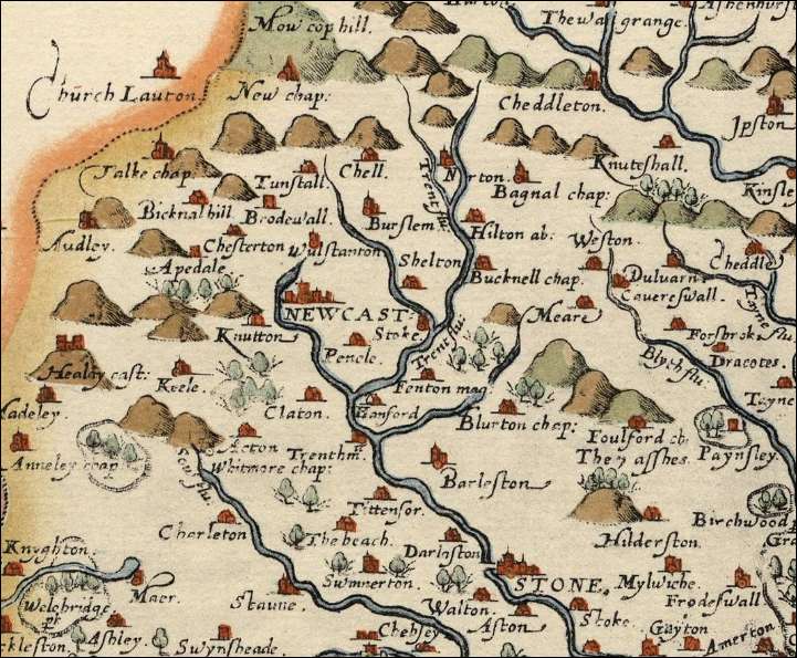
Map of North Staffordshire 1577
The Newcastle and Stoke-on-Trent area of North Staffordshire in 1577.
The Newcastle and Stoke-on-Trent area of North
Staffordshire in 1577
Flu = fluivium (Latin) = river - as in Trent Flu.
(River Trent)
Mag. = Mangna (Latin) = great - as in Fenton mag. (Great Fenton)
Chap. = Chapelry (Town with a Church of England Church)
| 1577 name | Modern name | |
| Mow cop hill | Mow Cop | |
| Talke Chap. | Talke | |
| Tunstall | Tunstall | |
| Chell | Chell | |
| Norton | Norton | |
| Bagnal chap. | Bagnall | |
| Bicknal Hill | Bignall End | |
| Brodewall | Bradwell | |
| Burslem | Burslem | |
| Hilton ab. | Abbey Hulton | |
| Weston | Weston Coyney | |
| Audley | Audley | |
| Chesterton | Chesterton | |
| Wulstanton | Wolstanton | |
| Shelton | Shelton | |
| Bucknell chap. | Bucknall | |
| Apedale | Apedale | |
| Caverewall | Caverswall | |
| Newcastle | Newcastle-under-Lyme | |
| Knutton | Knutton | |
| Meare | Meir | |
| Stoke | Stoke | |
| Forsbrook | Forsbrook | |
| Pencle | Penkhull | |
| Keele | Keele | |
| Blyth flu. | Blythe Bridge | |
| Fenton mag. | Fenton | |
| Claton | Clayton | |
| Hanford | Hanford | |
| Blurton chap. | Blurton | |
| Trentham | Trentham | |
| Barleston | Barlaston |
|
Part of a 16th Century
Staffordshire Map, by Christopher Saxton |
![]()
![]()