|
Meir,
Stoke-on-Trent,
Staffordshire.
Situated at the junction of the
main A50 road from Derby and Uttoxeter through Stoke-on-Trent and the
minor A520 road from Stone to Leek.
The village of Meir has always
been a gateway in to North Staffordshire and the Potteries area.....
1 .... in Roman times it was
situated on the Roman road Rykeneld Street which ran from
Derby/Uttoxeter, through Meir to Chesterton and then onto Chester.
2 .... the 1087 Domesday book records Normacot,
Weston (Coyney) and Caverswall which all centre on Meir. The village of
Meir was located on the boundary of the Pirehill and Totmonslow
Hundreds.
3 .... in 1223 Henry de Audley granted land to the monks
of Hulton Abbey, this included land
in Normancote (became Normacot Grange) and monks passed through
the village of Meir on their way to the Grange at Normacot.
4 .... today the A50 major trunk road enters the city at
Meir.
|
The
following maps show Mearlane end (Meer Lane), Meare (Meer) and
Normacot Grange.
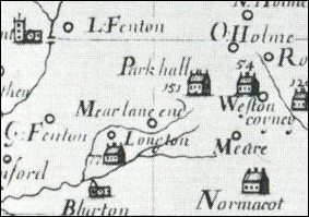
Plot's map of North
Staffordshire c.1670
showing Mearlane end
- click map for large view -
The development of
the footpath and tracks developed in this area.........
"Tracks led south-eastward from Meare Lane End to Stone and
northward over Sandford Hill to Hanley, Adderley Green, Leek, and
the north-east of the county by the 18th century. The
turnpiking of the Newcastle to Uttoxeter road under an Act of
1759, of the road to Stone under an Act of 1771"
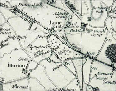
William Yates Map of Staffordshire
1775
showing Meer and Meer Lane
- click map
for large view -
|
1539 Muster Roll -
an indication of the importance of Meir was the number of able men it
could muster in time of need....
In 1539, Henry, Lord of
Stafford, came to Penkhull and inspected the men over 16 years old who
were able to serve in King Henry VIII's wars with France. The muster
roll covering Pirehill Hundred, listed several local settlements and the
number of men they could supply. Trentham had 35 able men, Meir had 33,
Fenton and Longton 22 men, Norton 16, Penkhull 18 and Stoke 4; Fulford
and Great Fenton 44 men, Tunstall 31 and Hanley 9.
"The
principal road through Fenton is the road from Uttoxeter to
Newcastle which crosses the area as King Street and City Road.
This follows the course of the Roman road called Ryknield Street as
far as the junction of Vivian Road and King Street where it inclines
westwards and runs directly to Stoke Bridge.
The road occurs as a highway in 13thcentury records. It was
subsequently turnpiked under an Act of 1759; the toll house for
this stretch was situated first at Meir and was replaced by a toll
house on the Longton boundary at the Foley under an Act of 1763."
A
History of the County of Stafford: Volume 8 (1963), pp. 205-224.
"..... the wider of the two valleys is the route
of a Roman road from Derby and has long been one of the main ways of
access into North Staffordshire from Derbyshire. It was on this road,
roughly at the point where the Anchor Brook and the stream from Goldenhill meet, that the hamlet of Lane End or Meare Lane End grew up
in the late 17th century under the influence of coal and ironstone
mining and ironworking.
In 1666 13 houses in
Longton were chargeable to Hearth Tax and 12 in Meare Lane End.
Meare Lane End was mentioned c. 1680 by Gregory King who noted that
there were 5 or 6 houses in Longton itself. Tracks led
south-eastward from Meare Lane End to Stone and northward over Sandford
Hill to Hanley, Adderley Green, Leek, and the north-east of the county
by the 18th century.
A History of the
County of Stafford: Volume 8 (1963), pp. 224-246.


|