Maps of Stoke-on-Trent & North Staffordshire
![]()
Maps of Stoke-on-Trent &
North Staffordshire
![]() | main
map index |
| main
map index |
Extract from William Yates 1775 Map of Staffordshire - showing the Cobridge area
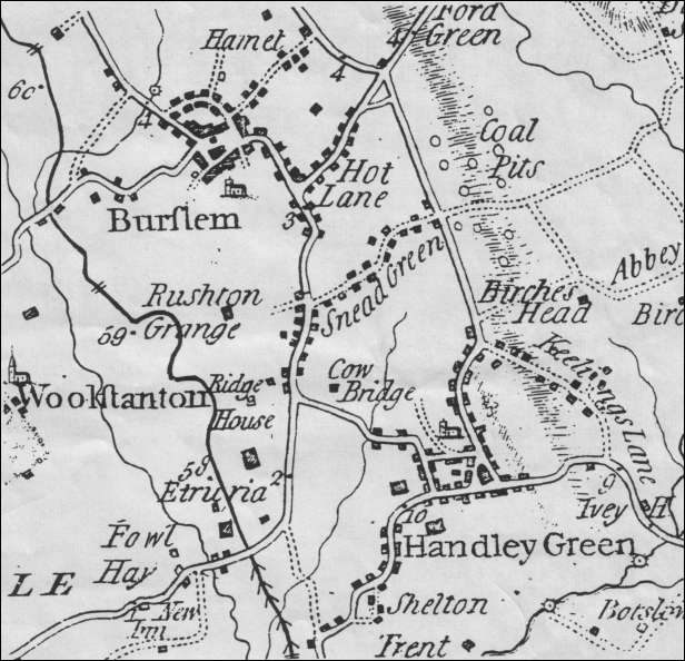
Extract from William Yates 1775 Map of
Staffordshire - showing the Cobridge area
The extract from William Yates’ Map of Staffordshire above shows the area between Burslem and Hanley (Handley Green) in 1775.
Then the main road between these settlements ran down Nile Street and along Elder Road before dividing one branch leading along the present Century Street to Hanley and the other passing through Etruria to Newcastle-under-Lyme.
These roads were turnpiked in 1765 largely as a result of the efforts of Josiah Wedgwood.In the 1680s there were only three or four small houses at Cobridge but by the mid 1770s a distinct settlement had come into existence in the vicinity of the cross road formed by Sneyd Street, Grange Street and Elder Road.
The settlement included a number of Potworks most of which had been set up in the third quarter of the 18th century. These began to expand rapidly after the turnpiking of the roads and the construction of the Trent and Mersey Canal (shown by a thick black line on the map) between 1766 and 1777.
Four buildings are separately identified on the map: The Ridge House and Etruria Hall both of which lay in the Parish of Stoke-upon-Trent; and “Cow Bridge”, probably the predecessor of Cobridge Hall, which had disappeared without trace by the end of the l8th century, and the farmhouse at Rushton Grange.
| See Thomas Hargreaves map of Cobridge 1832 |
|
- take a 'walk' around this area |
![]()
![]() | main
map index |
| main
map index |
07/12/2001