|
Dimsdale
- 'Mystery of Roman Road is just par-for-the-course'
  
click the
"contents" button to get back to the main index & map
next: Bradwell and the Sneyd family
previous: Packhorse Lane - the lifeline of the Potteries
|
Historian Fred Hughes
writes....
Going
back a few weeks to Winton Square in Stoke, historian Steve Birks
established that the Roman Road passed by the railway station and
travelled along the Fowlea Valley to Etruria.
“From
this point though,” says Steve, “it’s almost impossible to follow the
route from Etruria, it has simply disappeared. And yet if we accept that
Roman roads followed a straight line, it is feasible to suppose that the
Rykeneld Street from Derby to Chester climbed from Etruria to May Bank
giving a relatively flat approach to the Roman Station we know was based
at Chesterton.”
But, in
the absence of proven documents and only limited early references,
following the road from May Bank to Chesterton has to be guesswork.
“Even
the historian John Ward, writing in 1843, was unable to place the exact
line,” says Steve. “Ward surmised that the road followed a dingle path
to Wolstanton Marsh and through Wolstanton village to Port Hill and to
Bradwell Hall in the direction of Chesterton. But this is not as clear
as he suggests.”
|
Indeed, a more direct route from May Bank can even now be seen to
follow a line occupied today by Rathbone and Belmont Avenues, passing west
of Wolstanton High School into Hollinshead Avenue and across Wolstanton
Golf Club. Golf historian Alan Mountford tends to agree.
“I
considered all this when I was writing my centenary history on the golf
club,” he acknowledges.
“I discovered the lane leading to the clubhouse was an ancient bridle
path crossing Dimsdale Parade and Hassam Parade to arrive at the A34,
which was an old coaching road. My book shows a map of the Dimsdale
Estate in 1877. It indicates a newly erected farm close by a Saxon barn.
There are a couple of thrilling photographs as well taken in 1900. One
shows Dimsdale Hall having been renovated in the 17th century
where the front is clad with a brick and stone built Jacobean façade.
The other, taken about the same time, shows the hall from the rear. And
this clearly shows it to be a fine Elizabethan mansion. But I found no
references to the Roman Road.”
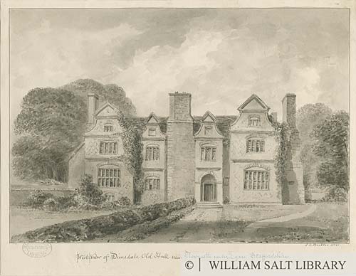
'West View of
Dimsdale Old Hall near Newcastle under Lyme, Staffordshire,'
showing a house with brick pedimental gables and large
chimney stacks.
©
William Salt Library, Staffordshire Past Tracks
Dimsdale
estate was purchased by the golf club in 1903. The old house began to
decline and was redeveloped in the 1920’s as a clubhouse. Eventually the
last remnants of Dimsdale Hall were demolished in 1947.
“We did
keep a memento,” says club chairman Bert Maxfield. “In the restaurant
you’ll see we have preserved part of the oak-framed wall with wattle and
daub rendering which we have encased in glass. It’s a reminder of our
ancient past.” |
The
Dimsdale estate came into existence in 1608. According to Ward it was
the seat of the Brett family of ancient standing, but he is unable to
provide its lineage. In the early Victorian period the hall was owned by a
family named Bennett. Bert offers an interesting notion to why he believes
the Roman Road passed by here and walks me over to the 5th
green.
“Have a
look at that and tell me what you think,” Bert suggests. And there, for
some 60 metres under the well-manicured grass are long undulations of
earth mounds that look to me as though they had once been ploughed
furrows.
“There’s
been much speculation as to what those ridges are,” continues Bert. “And
there is a thought that they may have been part of a Roman station in this
vicinity. But I suspect we’ll never know if this is true.”
Bert also
directs me to another ridge, one that is less prominent but clearly marked
running across the 16th to the 8th fairway as if it
was a planned thoroughfare, an access to the old farm perhaps.
“The
farm has gone now and a builder has begun to erect a few valuable houses
on the old barn site,” says Bert.
Alan’s
book provides some remarkable information about the site’s development. In
1924 for instance the course was only 8 holes rented from the farmer. The
same year it was extend it to its present 18 holes.
“The
clubhouse was opened twelve months later,” says Alan. “It was still very
primitive and electricity wasn’t installed until 1934. After this things
moved on a pace but it wasn’t all plain sailing. In 1966 after a long
fight we were able to fight off a council order to acquire the land for
a public park.”
Apparently the council offered the club some land at Keele as a straight
transfer. The offer was rejected and ironically the land at Keele was
developed as a popular municipal course. So good came out of it whichever
way you look at it. And Wolstanton Golf Club went from strength to
strength.
“Membership is very high,” says club secretary Valerie Keenan. “We are
very proud of what we’ve achieved and our members have a great feeling of
companionship and belonging.”
|
But in
all this digression am I any closer to discovering if the Roman Road
passed this way. The question remains, did the Rykeneld Street travel
through Dimsdale or Bradwell?
“Ward is
unusually vague about it,” says Steve. “His reference to correspondence
between two Cambridge University academics is far from clear. In recent
times archaeological digs have discovered that the Roman road passed
through Dimsdale. Part of it was unearthed by Wolstanton High School in
the 1960s when a twenty-foot wide buried road surface of thick sandstone
blocks on a foundation of clay on gravel laid in typical Roman method was
found. Later excavations in 1995 revealed another section of what was
thought to be the same road in a back garden close to Wolstanton Golf
Course. But that is all.” |
And so we
will let the Romans sleep, oblivious to our passing interest. But I reckon
a well-swung driver could easily send a golf ball from the golf club into
the heart of the Chesterton garrison. That’s how close history is.
next week: the lane to Bradwell Wood
click the
"contents" button to get back to the main index & map
next: Bradwell and the Sneyd family
previous: Packhorse Lane - the lifeline of the Potteries
|