![]()
![]()
![]()
Shelton (and the Ridgway Family)
A walk around the Howard Place and Cauldon Place area of Shelton, covering the development of the streets and houses in the area, the Ridgway family and the churches in the area.
also see a walk along Stoke Road to Howard Place and Snow Hill
(it will help
you to read the introduction first
and to look below - at the tour order
and list of maps/documents)
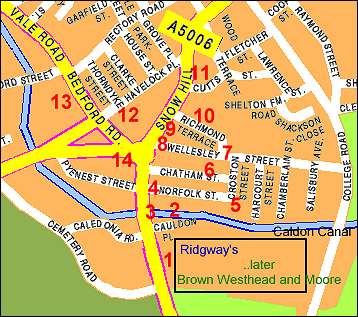
Click the map to go to a location
- or select from the list below -
![]()
![]()
| Locations & photos of the tour (click on the numbers in left column) | |
| intro | Introduction and location map |
| 1 | Cauldon Collage and Ridgways factory. |
| 2 | Caldon Canal, the wharf and locks. |
| 3 | Shops / houses in Stoke Road. |
| 4 | Norfolk Inn, the brickworks and glassworks. |
| 5 | Croston Street and its houses. |
| 6 | Chatham Street and the alley to Wellesley Street. |
| 7 | Wellesley Street and its houses. |
| 8 | Scrivener's Architects. |
| 9 | The Hollies and Richmond Villa in Snow Hill (Masonic Lodge) |
| 10 | Richmond Street and the school. |
| 11 | Cutts Street and the Bell & Bear. |
| 12 | Havelock Place, houses and Ridgway Memorial Chapel. |
| 13 | Bedford Chapel. |
| 14 | Berks - wholesale grocer and The Elms. |
- back to the map -
![]()
- back to the map -
![]()
![]()
This walk is based on notes by Andrew
Dobraszczyc,
web pages and photographs by Steve Birks during the walk (July 2000)
questions/comments/contributions? email: Steve Birks
![]()