![]()
![]()
|
|
|
The Potteries in 1086: Domesday Book Records of Stoke-on-Trent
|
|
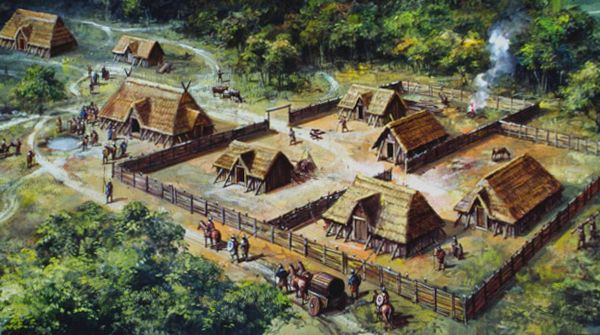
Small settlements such as Penkhull, Wolstanton and Burslem would have consisted of timber-framed buildings with thatched roofs surrounded by fields and woodland. |
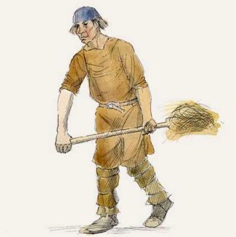
Most people living in the area in 1086 would have worked on the land, cultivating crops and tending livestock. |
|
|
||
|
|
||
| At a Glance: The Stoke-on-Trent Area in 1086 and Today |
||
| Feature | 1086 (Domesday Book) | Today |
| Administrative area | Pirehill & Totmonslow Hundreds | City of Stoke-on-Trent (plus surrounding Staffordshire districts) |
| Settlement pattern | Scattered manors and farming hamlets | Continuous urban area with six historic towns |
| Largest settlements | Penkhull, Wolstanton, Trentham, Stoke | Stoke-on-Trent urban area (~250,000+ population) |
| Economy | Agriculture (arable farming, livestock, woodland use) | Manufacturing, services, retail, education, heritage tourism |
| Population | A few thousand across the whole district (estimated) | Over 250,000 in the city area |
| Landscape | Woodland, open fields, heath and marsh | Urban landscape with parks, housing and industrial legacy sites |
| Transport | Tracks, footpaths and river crossings | Road, rail and canal network |
| Industry | None recorded (domestic craft only) | World-famous pottery and ceramics industry (plus diverse modern economy) |
|
|
| Domesday and
Stoke-on-Trent
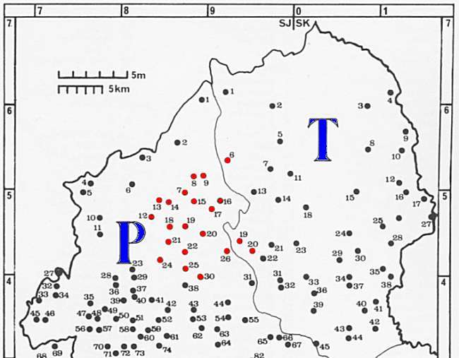
The map below highlights Domesday settlements within the area that would eventually become Stoke-on-Trent, plotted on Dr Plot's map of North Staffordshire (c.1670). The 'Summary of the survey' lists the ownership, population and resources recorded for each settlement in the 1086 Domesday Survey. |
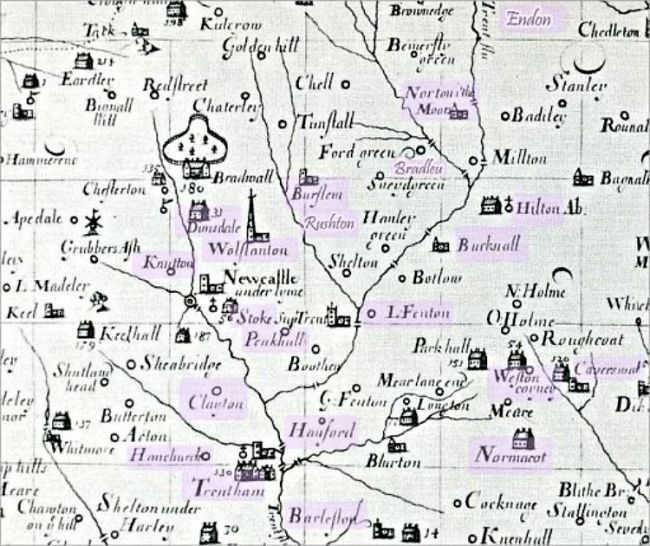 Dr Plot's map of North Staffordshire c. 1670 with the locations from the the 1086 Domesday survey highlighted |
|
|
|
|
Summary of the survey.. The table below summarises the Domesday Book entries for settlements within the area of modern Stoke-on-Trent. It records the number of households, the amount of ploughland, the size and value of each manor, and the landholder responsible for it in 1086. The entries are grouped according to the principal landowners recorded in the survey.
|
| 'Land of the King...' | ||||||
| Settlement | Households | Plough lands | Size | Land type | Value | Held by |
|
BUCKNALL [BVCHENOLE] |
Land for 3 ploughs | third part of a hide | Ketel | |||
|
|
||||||
|
ENDON [ENEDVN] |
Land for 1, or 2 ploughs | Dunning | ||||
|
|
||||||
|
PENKHULL
[PINCHETEL] |
17 villagers and 6 smallholders with 8 ploughs. | Land for 11 ploughs. In lordship 2; | 2 hides, with its dependencies |
Meadow, 2 acres; Woodland 1 league long and 2 furlongs wide. |
Value £6. | Earl Algar |
|
|
||||||
|
TRENTHAM [TRENHAM] |
5 villagers with 1 smallholder and a reeve have 3½ ploughs. A priest and a freeman have 2 ploughs; 3 villagers and 6 smallholders with 1 plough. |
Land for 3 ploughs. In lordship 1; | 1 hide. | Woodland 1 league long and ½ wide. | Value before 1066, 100s; now 115s. | Earl Algar |
|
|
||||||
|
WOLSTANTON [WLSTANETONE] |
In lordship 2 ploughs; 14 villagers and 2 smallholders with a priest have 8 ploughs. |
2 hides, with its dependencies | Woodland 1 league long and 1 furlong wide. | Value before 1066, 100s; now £6 | ||
|
|
| 'Land of Robert of Stafford...' | ||||||
| Settlement | Households | Plough lands | Size | Land type | Value | Held by |
|
BARLASTON [BERNVLVESTONE] |
4 villagers and 3 smallholders with 1 plough. In lordship 1, with 1 slave; |
Land for 6 ploughs. | ½ hide | Meadow, 6 acres; woodland 3 acres. | Value 40s. | Helgot / Augustine |
| Robert also holds ½ hide in BARLASTON, and Helgot from him. Augustine held it; he was a free man. | ||||||
|
|
||||||
|
BURSLEM [BARCARDESLIM] |
1 villager and 4 smallholders with 1 plough. | Land for 2 ploughs. | Alder grove, 2 acres. | Value 10s. |
Wulfgeat / Alfward |
|
| Robert holds the third part of 1 hide himself in BURSLEM. Alfward held it; he was a free man. | ||||||
|
|
||||||
| BRADELEY [BRADELIE] | In lordship 1; 3 slaves; 3 villagers and 6 smallholders with 2 ploughs | Land for 4 ploughs. | Meadow, 4 acres; woodland 2 leagues long and 1 wide | Value 40s. | Tanio / Wulfgeat / Alfward | |
| Robert also holds in BRADELEY ½hide. Tanio holds from him. Wulfgeat and Alfward held it; they were free. | ||||||
|
|
||||||
|
CAVERSWALL [CAVRESWELLE] |
In lordship 1; 10 villagers and 2 smallholders with 3 ploughs. | Land for 4 ploughs | 1 virgate of land. | Meadow, 6 acres; woodland 1 league long and ½ wide | Value 30s. | Arnulf / Wulfgeat |
|
Arnulf holds from him. Wulfgeat held it; he was a free man. A half of Stoke(-on-Trent) [STOCHE] Church, with 1/3 carucate of land. |
||||||
|
|
||||||
|
NORTON [NORTONE] |
6 Villagers and 3 smallholders with 3 ploughs. | Land for 4 ploughs. | 2 hides | Woodland 3 leagues long and 2 leagues wide. | Value 40s. | Godric / Wulfgeat |
| Robert holds 2 hides himself in NORTON (-in-the-Moors) and in its dependencies. Godric and Wulfgeat, who were free, held it. | ||||||
|
|
||||||
|
RUSHTON [RISCTONE] |
3 villagers and 3 smallholders with 1 plough. | Land for 3 ploughs. | third part of 1 hide | Woodland 1 league long and ½ wide. | Value 10s. | Wulfgeat |
| Robert also holds the third part of 1 hide in HULTON and RUSHTON. Wulfgeat holds from him. He held it himself before 1066. | ||||||
|
|
||||||
|
WESTON [WESTONE] |
5 villagers with 2 ploughs. | Land for 3 ploughs. | 1 virgate of land. | Woodland 1 league long and ½ league wide. | Value 10s. | Arnulf of Hesdin / Wulfric |
| Robert himself holds in WESTON 1 virgate of land. Arnulf of Hesdin holds from him. Wulfric held it. | ||||||
|
|
||||||
| 'Land of Richard Forester...' | ||||||
| Settlement | Households | Plough lands | Size | Land type | Value | Held by |
|
CLAYTON [CLAITONE] |
In lordship ½ plough; 4 villagers and 6 smallholders with 1½ ploughs. | Land for 3 ploughs. | ½ hide. | Woodland 1 league long and ½ wide. | Value 10s | Nigel / Saegrim |
| Nigel holds from him. Saegrim held it; he was a free man. | ||||||
|
|
||||||
|
DIMSDALE [DVLMESDENE] |
5 villagers and 2 smallholders with 2 ploughs. | Land for 2 ploughs. | 1 virgate of land. | Meadow, 4 acres; woodland 12 furlongs long and 6 wide. | Value 10s. | Gladwin / Godwin |
| In DIMSDALE 1 virgate of land. Gladwin and Godwin held it; they were free. | ||||||
|
|
||||||
|
HANCHURCH [HANCESE] |
2 villagers and 7 smallholders with 1½ ploughs. | Land for 2 ploughs. | Three parts of half a hide. | Meadow, 1 acre; woodland 2 furlongs long and 1 wide. | Value 5s. | Pata - a free man |
|
|
||||||
|
HANFORD [HENEFORD] |
Land for 1 plough. | 1 virgate of land. |
Waste. A small wood 20 perches in length and width. |
Value 2s. | Nigel - Tholf held it. | |
|
|
||||||
| KNUTTON [CLOTONE] | 4 villagers with 1 smallholder have 1 plough. | Land for 2 ploughs. | 1 virgate of land. | Meadow, 4 acres. | Value 5s. | Godwin - a free man |
|
|
||||||
|
NORMACOT [NORMANESCOTE] |
Land for 1 plough. In lordship 1. |
1 virgate of land. | Woodland 3 furlongs long and 2 furlongs wide. | Value 2s. | Aelmer / Wulfric | |
| Aelmer and Wulfric hold from him. Wullfmer held it; he was a free man. | ||||||
|
|
||||||
| 'Land of the King's Thanes...' | ||||||
| Settlement | Households | Plough lands | Size | Land type | Value | Held by |
|
FENTON [FENTONE] |
Land for 3 ploughs. | 1 virgate of land | Waste. | Alfward | ||
|
|
|
The Hundreds of Pirehill and Totmonslow Long before the Domesday Survey was compiled in 1086, England was divided into administrative districts known as Hundreds. Dating back to the Anglo-Saxon period, these divisions formed the basis of local government and were used for taxation, military organisation and the administration of justice. When King William I ordered the great survey that became known as the Domesday Book, his officials organised much of their work around these existing Hundreds, recording landholdings, resources and values within each district.
|
|
- those marked in red eventually became the Stoke-on-Trent area - |
|
carry
on exploring »
the definitions in the Domesday Book |
more on
Pirehill and Totmonslow Hundred
|
|