|
|
| Stoke-on-Trent Districts: Meir |
![]()
![]()
![]()
|
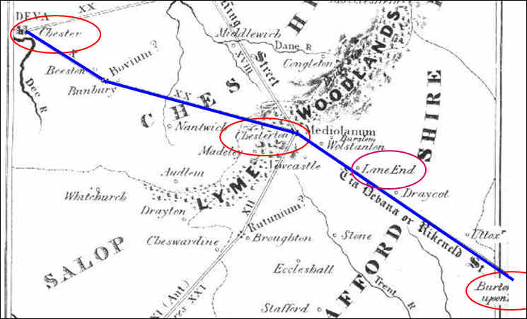
Meir and the Roman Road
Charter of the Abbey of Hulton "The
Foundation Charter of the Abbey of Hulton, dated 1223, contains a
description of the possessions, granted by Henry de Audley, to the
Abbots and Monks; which includes lands in Normancote (became
Normicot Grange, now Normacot), adjoining to Longton and Lane End.
This estate is said to
be bounded by the old course of the river Blithe (now river Blythe), as
far as a place called Wetmeresbrook, (or Wetmotesbrook), which must be
near Bthythe Bridge, and from there to run up Rykeneld Street and
through the village of Mere as far as the spring which flows from the
intakes of Mere. ("De assartis de Mere" - Assartum signified land
reclaimed from a wood or waste). Here we have a
document more than seven hundred years old which identifies Rykeneld
Street. Route
of Rykeneld Street "This road proceeded
from Blyth Marsh, in a direct course towards Lane End… the Sutherland
Road in Lane End is a continuation of it; at the north end of which it
again unites with the turnpike road, and passing the church, goes on to
Lane Delph; but there the turnpike road diverges a little, and the
Rykeneld Street goes, or rather did go, in a direct line to the
pear-Tree Houses, and the Manor House of Little Fenton; then passing
Cauldon Place and Shelton Hall, a little on the left to Foul Hay House,
from whence it most likely proceeded up a hollow way or dingle to
Wolstanton Marsh; thence, perhaps, through the village of Wolstanton, to
the top of Port Hill, and along the present road towards Bradwell Hall,
in the direction of Chesterton; but we are unable, after considerable
diligence, to discover any traces of the Rykeneld Street between
Wolstanton and Chesterton. The Borough of Stoke-upon-Trent" John Ward, 1843
Meir and the Domesday Book
P26 Normacot
|
questions / comments / contributions? email: Steve Birks
26 November 2007