|
Cobridge
- 'the Victorian suburb en-route to Burslem'
  
click the
"contents" button to get back to the main index & map
next: Packhorse Lane - the lifeline of the Potteries
previous:
the changing face of
Cobridge
|
Historian Fred Hughes
writes....
Had
they been about today the Audley family would have been as rich as the
Dukes of Westminster. Wealthy beyond belief for his times, the richest of
these conquering descendants from Normandy was Henry Audley who founded
the Cistercian abbey at Hulton. Sponsoring the hooded brethren was the
aristocratic method for making sure the stairway to heaven lay
unobstructed.
“Throughout the seasons from 1223 until 1539 the abbots of Hulton would
dispatch teams of monks to work the land that Henry had donated,” says
historian Steve Birks. “And there was plenty of it. One of these farms was
established two miles away at Rushton Grange, a place these days we
generally call Cobridge.”
|
That
route would have crossed the Trent travelling uphill through Birches Head
and Sneyd Green before descending along Sneyd Street.
“Fortunately we can still follow this path,” continues Steve. “Towards the
Cobridge side it passes by the Raven pub along Grange Street, over
Waterloo Road and on to the council estate where the abbey farm buildings
were once situated.”
But a
nearby ancient road can also be followed. Long before the Audley’s the
whole of the western side of the ridge from Chell to Hanley was covered in
woodland. This was part of what was known as the New Forest that stretched
from Tunstall to Tixall. We can still see concentrations of it in such
places as Moddershall.
“There
is evidence that the Audley’s hunted wild boar and deer along the ridge
particularly when the policy of disafforestation began under King John
in 1200,” says Steve. “By this time there was probably a principal path
that travelled through the forest from the Raven along Elder Road and
Nile Street crossing by St John’s church to join other western routes to
Heleigh where the Audley’s constructed their castle in the first quarter
of the thirteenth century. Names of modern streets – Grove, Elm and
Hawthorn – indicate the once bucolic state of the land.”
|
These
modern-defined streets originate from the spine of Waterloo Road.
Demographic analyst Elizabeth Hughes, points out some of the subsequent
changes as urbanisation took hold to transform the landscape.
She tells
me, “In 1815 major road improvements resulted in the availability of
building land. Waterloo Road was specifically designed to link the towns
of Hanley and Burslem, removing the need to use the convoluted lanes. In
the late-Victorian period this land became a desirable suburban location
for aspiring middle-classes. By 1900 Waterloo Road hosted a settlement of
superior Victorian houses while the streets to Elder Road became
structured terraces with rear gardens and small walled front courtyards.”
These
conservative settlements were paid for with new money as the
middle-classes put distance between themselves and the hoi polloi. The
fine houses came with better services and leisure facilities. Cobridge had
its own railway station and later a pleasure park with tennis courts.
“Post
war housing needs however posed different problems,” continues
Elizabeth. “The shortage of social housing in Stoke on Trent saw
Cobridge becoming a multi-occupancy bed-sit district. Indeed there was a
notable incident of squatting in 1959 when two families occupied the
six-bedroom Victorian house at 205 Waterloo Road. This was the former
home of the writer Arnold Bennett. It took almost two years to relocate
the squatters into council houses.”
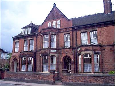
Arnold Bennett's
home No 205 Waterloo Road
Alongside
Cobridge Park Elder Road gives way to Nile Street and Hot Lane.
“Nile
Street was an early lane,” says Steve. “It had originally been part of Hot
Lane but was improved around 1800 possibly as a result of turnpike
legislation.”
|
Nearby
the potteries of Dudson and William Moorcroft operate as elder statesmen
to the studio artists who come to set up business along this stretch of
the lane. Some stayed; some companies such as James Cullen’s Culinaire
Crusader pottery left. But one new studio has recently opened in the
former weighbridge offices of the obsolete Sneyd Colliery called Air Waves
Studios. Julie Goold is one artist who is based here.
“I was a
gilder at Royal Doulton before the redundancies and closure,” recalls
Julie. “What do you do with yourself when you’re over forty and the
industry you’ve spent your life in suddenly collapses? Well I followed my
dream. Went to university, got my degree in fine art and joined this
workshop along with others in similar situations.”
Just as
the early potters did in past times Julie joined a community of artists.
In this Nile Street art studio you’ll find ex-accountant Linda Birmingham,
ex-electrician Stuart Porter, former potters like Julie Newbold and ex-Coalport
and Spode china flower maker 43 year old Angela Pike.
“I worked
for all the top companies but I feel as though I’ve been released to do
what I believe is what I’m good at,” says Angela. “It looks as though my
efforts have been recognised for I’ve been nominated for an achievement
award.”
Another
artist based at Air Waves has already made a name for himself with a
technique that presents a graphic view of high curves enabling him to
capture an angle of 180° delivering an image with barrel distortion.
“It is
a process that enables me to capture a storyline rather than a single
scene shot,” says painter Rob Pointon. “For instance I’ve been
commissioned to reproduce the scene of the recent fire that destroyed
some important buildings at Royal Doulton. A 180 degree view lets me
portray the scene of activity on that night capturing the fire fighters
working at several locations. By using this format I am able to
reproduce a documentary of events as well as pinpointing a series of
centrepieces, but fluid so that nothing is missed.”
|
And here
at the head of Nile Street is where the Royal Doulton pottery stands
derelict and abandoned. A place that employed and fostered generations of
legendary artists and designers waits in submissive gloom for the
bulldozers to move the Mother Town towards its next stage of change.
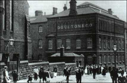
Workers outside the
Doulton factory at the turn of the century (1900's)
 Cobridge - the road from Hanley to Burslem
A walk around Cobridge - a
Victorian Suburb
Waterloo Road
next week: Burslem & the packhorse lanes
click the
"contents" button to get back to the main index & map
next: Packhorse Lane - the lifeline of the Potteries
previous:
the changing face of
Cobridge
|