|
|
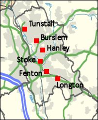
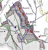
Stoke-on-Trent is unique among English cities in having been formed from six historic towns: Tunstall, Burslem, Hanley, Stoke, Fenton and Longton.
Each town developed its own character, industries and civic identity, yet together they became known worldwide as The Potteries. |
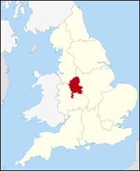
Stoke-on-Trent is located in the north of the County of
Staffordshire, England, U.K.

| Why It Is Called The Potteries |
|
The city owes its worldwide reputation to the pottery industry, which flourished here from the 17th century onwards. Rich local deposits of clay and coal, combined with skilled craftsmen and innovative manufacturers, made the district the leading centre of ceramic production in Britain and one of the best known in the world. |
Stoke-on-Trent
is known as "The Potteries" because its history is
inseparable from the ceramics industry. The area became the
global centre of pottery production thanks to a lucky abundance
of natural resources: local clay for the pots, salt and lead for
glazing, and coal to fire the kilns.
While
pottery has been made here since the 17th century, the region
rose to fame during the Industrial Revolution. Visionary figures
like Josiah Wedgwood moved production from small cottages into
large-scale factories, while Josiah Spode II later perfected
"fine bone china," making high-quality ceramics
affordable for the masses.
The
industry was further fueled by the opening of the Trent and
Mersey Canal in 1777. This vital transport link allowed raw
materials to flow in and finished goods to be exported
worldwide, forever linking the identity of the city to the craft
of the potter.
|
The
Bottle Kiln
|

Explore
the bottle kiln »
|
The bottle kiln is the definitive symbol of Stoke-on-Trent, a city world-famous as "The Potteries" for its role as the global heart of ceramic production.
Purpose: These towering brick structures were used to fire ceramics at temperatures exceeding
1,000oC
Design: The name refers to the distinctive outer brick "hovel" or chimney, which protected the inner oven from the elements and created a natural draught to feed the coal fires.
The Skyline: At the industry's peak in the early 20th century, as many as 2,000 kilns dominated the skyline of the city's six
towns.
Working Conditions: The air was often thick with coal smoke and soot, creating a landscape sometimes described as a "smog and dusty hell," yet it fostered a unique community identity built on skilled
craftsmanship.
The
Decline: The Clean Air Act 1956 effectively ended the use of coal-fired bottle ovens, leading to their replacement by cleaner gas and electric tunnel kilns
|
|
The 19th-century potter's life was defined by a harsh transition from traditional craftsmanship to the relentless demands of the Industrial Revolution. While the era produced some of the world's finest ceramics, the people behind the wheel—men, women, and children—often faced grueling conditions, extreme health risks, and a standard of living that rarely matched the beauty of their work. |
Rapid Expansion:
-
By 1800, the industry employed between 15,000 and 20,000 workers in around 150
factories.
-
Living in Shadow: Potters typically lived within a mile or two of the "potbanks" (factories), their homes overshadowed by massive bottle-shaped kilns that filled the air with smoke and
soot.
-
Specialised Roles: Work was highly segmented. A worker might spend their entire career in one specific area—such as the "clay end" for shaping or the "decorating end" for painting—often knowing little about other parts of the factory
The Hazards of the
Craft:
Daily life was physically taxing and frequently shortened by "industrial diseases"
-
"Potter's Rot": Potters constantly inhaled fine flint and clay dust, leading to silicosis or "Potter's Rot"—a deadly lung disease. In 1864, male potters' life expectancy was nearly 10 years lower than the national
average.
-
Lead Poisoning: Workers who applied glazes (dippers) or painted designs were exposed to lead and arsenic. Symptoms included "wrist drop," stomach disorders, and
paralysis.
-
Extreme Heat: Workspaces were often uncomfortably hot or unheated. "Mould runners" (usually young children) ran miles each day between unheated workshops and drying rooms heated to over 50°C.
The Social
Reality:
Despite the "abject poverty" that many faced, the community was known for its strong character and pride in its
craft.
-
Child Labour: Until mid-century reforms, children as young as six worked 12-to-14-hour days for meager wages, often used to help their families
survive.
-
Family Tradition: Jobs were often secured through relatives already in the
industry.
-
Wages: While skilled male potters could earn 30 to 40 shillings a week—relatively high for the time—they often worked 72-hour weeks to maintain that income
|
The geology of North Staffordshire
|
Explore
the geology »
|
The
unique landscape of Stoke-on-Trent is shaped by a distinct
"layer-cake" geology of coal, sandstone, ironstone, and
various clays.
Crucially,
the area sits on a geological sweet spot: natural erosion has
stripped away the top layers of earth just enough to leave rich
coal seams preserved, yet shallow enough to be easily reached.
This
rare overlap—having both the raw materials (clays) and the fuel
(coal) in one accessible location—directly fueled the birth and
success of the North Staffordshire Potteries.
The coal found in Stoke-on-Trent was uniquely suited for pottery production because it was primarily long-flame coal. This specific characteristic offered several critical advantages for firing large pottery kilns.
|
The
beginnings of the River Trent:
-
The River Trent begins its journey just north-west of Stoke-on-Trent, near Biddulph and Mow Cop. It starts as a small stream about 700 feet up, quickly flowing into Knypersley Pools, where it joins up with several other local
streams.
-
As it winds through the city, the river is surprisingly small—only about 2–3 feet deep and 4–6 feet wide. It passes through Norton and Hanley before reaching the centre of Stoke-upon-Trent.
-
Along the way, it’s joined by the Fowlea Brook, which runs through a nearby
valley.
-
Once it leaves the main city area, the Trent heads toward Hanford, where it meets the Lyme brook coming from Newcastle. From there, it flows into Trentham Park, filling the massive 80-acre lake. Its journey continues south-east, passing Barlaston and Stone as it heads toward Sandon and Weston-on-Trent.
|
|
For many centuries the area consisted of separate market towns and villages spread along the Trent valley and surrounding coalfields. During the 18th and 19th centuries the rapid growth of the pottery industry, together with canals, railways and mining, brought the towns closer together.
In 1910 they were officially federated to form the county borough of Stoke-on-Trent, later granted city status in 1925. |
-
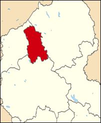
Stoke-on-Trent
is a federation of six much older towns forming a linear city
almost twelve miles long with an area of 36 square miles.
-
On
31st March 1910 a single county borough called Stoke-on-Trent
was formed.
-
It
consisted of the county borough of Hanley, the municipal
boroughs of Burslem, Longton and Stoke, together with the
urban districts of Tunstall and Fenton.
-
On 5th June, 1925 the county borough of
Stoke-on-Trent was elevated to rank of City.
|
|
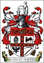
The motto of the
City of Stoke-on-Trent is Vis Unita Fortior
"United Strength is Stronger" |
Arms were granted to the new county borough
in 1912.
They were made up of devices
previously used by the constituent six
towns.
More
on the Arms »
|
|

|
The novelist Arnold Bennett immortalised the district in his books by referring to it as The Five Towns. His
'Five Town' novels gave an insight into the everyday lives of
Potteries folk.
For literary reasons he omitted Fenton, although the real city has always consisted of six towns. His novels remain an important part of the cultural history of Stoke-on-Trent.
Although
he changed the names, many of the locations in Bennett novels are
based on "The five towns" and correspond to actual
locations in and around the Potteries district of North
Staffordshire. |
|
Insight
into "Potteries Folk"
Bennett’s
novels, such as The Old Wives' Tale and the Clayhanger family
saga, are masterpieces of Literary Realism.
-
Everyday
Realism: He moved away from Victorian romanticism to
describe the "unpoetic" lives of the working and
middle classes—pottery manufacturers, shopkeepers, and
artisans.
-
Atmosphere:
He vividly described the "smoke-thickened" air and
the unique landscape of bottle-shaped pottery kilns (ovens)
that dominated the skyline.
-
Cultural
Preservation: Because he wrote during a period of massive
industrial change, his books serve as a historical record of
the North Staffordshire dialect, social hierarchies, and the
character of the people. .
More
on "The Chronicler of the Potteries" » |
|

|
Josiah Wedgwood (1730–1795):
The "Father of English Potters," he founded the world-famous Wedgwood company in Burslem. He was also a prominent abolitionist and the grandfather of Charles Darwin. |
|

|
Clarice Cliff (1899–1972):
A legendary ceramic artist born in Tunstall, she revolutionized pottery design in the 1920s and 30s with her bold, colourful "Bizarre" ware. |
|

|
Sir Oliver Lodge (1851–1940):
A physicist born in Penkhull, Lodge was a true pioneer of wireless telegraphy and radio. While he is credited with key developments for the spark plug, his work significantly predated Marconi’s in the field of radio communication. |
|

|
Captain Edward John Smith (1850–1912):
Born on Well Street in Hanley, Smith was the Commodore of the White Star Line. He was famously known as the "Millionaire's Captain" because high-society passengers often refused to sail with anyone else. |
|

|
Reginald Mitchell (1895–1937):
Born in Butt Lane, Kidsgrove, Mitchell was the aeronautical genius who designed the Supermarine Spitfire. He developed 24 different aircraft designs during his short life, many of which won international speed trophies. |
|

|
Sir Stanley Matthews (1915–2000):
Often called "The Wizard of the Dribble," Matthews was born in Hanley and is a literal icon of English football. He is the only player to have been knighted while still an active professional and was the inaugural winner of the Ballon d'Or in 1956. |
|

|
Phil "The Power" Taylor (born 1960):
Widely considered the greatest darts player in
the history of the game, Taylor was born in Burslem and has won a record 16 World Championships. |
|

|
Robbie Williams (born 1974):
One of the world's best-selling artists, Robbie was born in Burslem. He has never forgotten his roots, often referencing the city in his work and supporting local charities. |
|

|
Lemmy Kilmister (1945–2015):
The founder of the heavy metal band Motörhead was born in Burslem.
In 2025 a bronze-cast statue of the
Motörhead frontman was unveiled in the singer's hometown of
Burslem, |
|